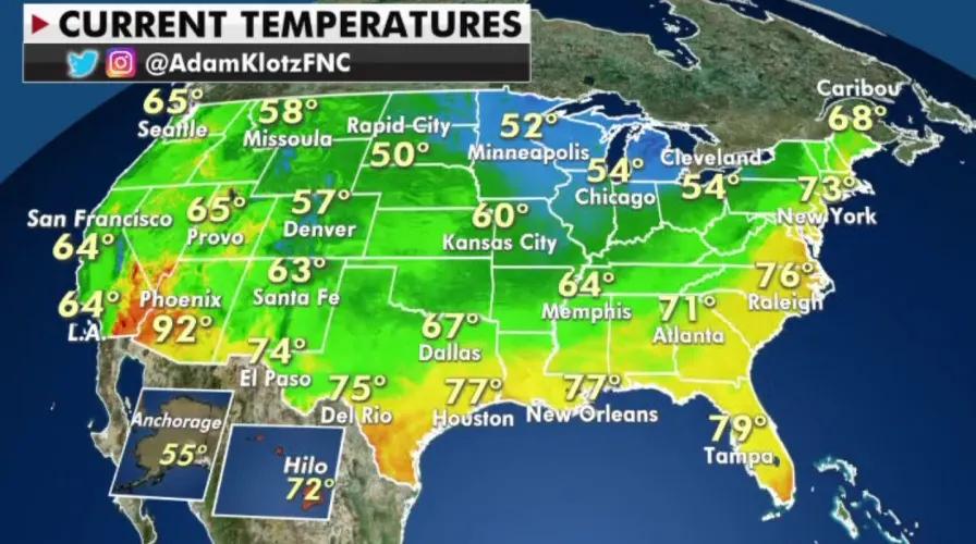
The world continues to see an increase in extreme weather events, yet weather continues to be an overlooked factor for many business operations globally. This issue is primarily driven by the inability of modern Numerical Weather Prediction (NWP) models to predict critical localized weather phenomena in a cost effective and timely manner.
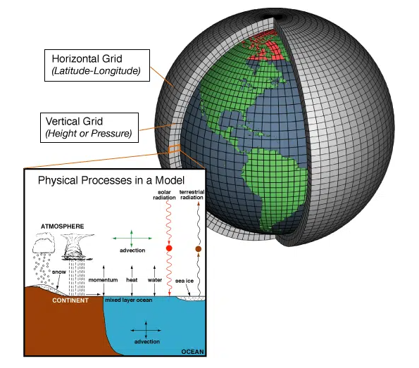
NWP models are designed to split the world into a three-dimensional grid that contains billions of grid cells both horizontally and vertically. Within each grid cell, meteorological governing equations are used to calculate physical processes that characterize how the air moves (ie., how heat and moisture are exchanged in the atmosphere) as the model steps forward in time. Atmospheric conditions, such as temperature, pressure, humidity, etc., are the same in each grid cell. Models run at lower resolutions (ie., > 4 km), such as global weather prediction models, are computationally inexpensive but significantly lack the level of detail needed to accurately represent local scale weather features. In low resolution simulations, the grid cells are larger, which means a larger area will contain the same atmospheric conditions. This presents a significant issue for regional weather predictions because local scale processes are misrepresented and overlooked, especially over complex terrain (ie., mountains and coastal regions), where terrain driven processes greatly influence localized weather conditions (ie., lake-effect snow, pop-up thunderstorms, etc.).
A way to resolve this issue is to run a (regional) model at a higher resolution (ie., < 4 km) since these models can enhance the representation of critical local scale weather features. However, running models at higher resolutions has its disadvantages. The grid cells in higher resolution models are smaller, which means the model domain consists of more grid cells than it would if it were run at a lower resolution. Smaller grid cells enable the model to characterize the interactions of local scale physical processes more effectively, but extensively increases computational cost and the time it will take to complete the simulation since more calculations are being computed.
TempoQuest, the leading provider of accelerated local scale weather forecast software, is working to solve this issue through the development of their enhanced weather forecast software product, AceCAST, which is an accelerated version of the Weather Research and Forecasting (WRF) Model. AceCAST is run solely on Graphics Processor Units (GPUs) instead of traditional Central Processing Units (CPUs), which enables users to run higher resolution simulations five to fifteen times faster at a much lower cost.
The preeminent benefits of localized weather prediction are evident in a recent weather event that produced localized substantial flooding and strong winds in California on October 24-25, 2021. California has a wide range of topography which creates local enhancements of precipitation and wind conditions. Upsloping, also known as orographic lifting, is the driving mechanism behind these local enhancements. Upsloping forces air to rise as it flows towards high terrain (ie., mountains) and results in amplified precipitation as shown.
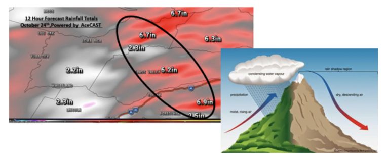
The illustration indicates a process known as “upsloping”, which AceCAST is better equipped to handle in contrast to present-day traditional weather models which may be attributed to AceCAST’s ameliorated localized prediction. Topography played a significant role enhancing the rainfall that caused the flooding just to the Northeast of Yuba City around Grass Valley, CA October 24-25, 2021.
On the morning of October 24th AceCAST was run at 1km resolution. The primary risk was flooding and high winds with a strong low-pressure system moving into the Western US. California has a wide range in topography which can create local enhancements both in wind and precipitation. Fig. 2 (below) shows the AceCAST 12-hour forecasted total rainfall along with an illustration of how these local terrain enhancements work. Given the wind flow pattern across the region a process called upsloping occurs on the windward side of a mountain range. The black circled region indicates areas that are forecasted to receive 2-7 inches of rainfall within a 12 hour period. The dark red regions, which indicate 5-7 inches of rainfall, are co-located near local mountain ranges.
According to the National Weather Service, more than a foot of rain hit Grass Valley during a 72-hour stretch on October 24, 2021; which included the 12-hour total rainfall simulated by AceCAST.
Another example of how topography played a role during the recent California storm are the wind speeds, as shown below. Higher elevations are more susceptible to higher winds along with complex terrain that can make for a wide range of wind speeds within a short distance. The later figure shows the damage caused by strong winds during this storm system.
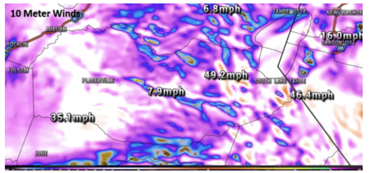
10 meter wind forecast at 5:00 PM local time October 24th, 2021 over California using 1km resolution powered by AceCAST.

A tree branch blocks 10th Street in Downtown Sacramento during a storm on Sunday Oct. 24, 2021
About AceCAST
AceCAST is a powerful cutting-edge software powered by Graphic Processing Units (GPUs) that enables the acceleration of the National Center for Atmospheric Research (NCAR) Weather Research and Forecasting Model (WRF). AceCAST is the product of a half-a-decade of punctilious research and development that empowers WRF users to secure striking performance optimizations using the superior massive parallelism of GPU hardware versus traditional Central Processing Unit (CPU) computation. AceCAST encompasses an ample set of refactored common WRF physics and dynamics modules, and namelist options with NVIDIA CUDA or OpenACC CPU programming techniques, allowing a wide swath of users to adopt AceCAST painlessly as a drop-in replacement for existing WRF configurations.
About TempoQuest
TempoQuest is an independent weather software vendor that was incorporated to revolutionize mesoscale weather forecast modeling and to simplify the forecast tasks for meteorologists. TempoQuest offers two software products, AceCAST, or accelerated WRF software, and WSV3, a highly advanced weather visualization and storm tracking software. Additionally, TempoQuest offers WRF On-Demand, a cloud application that greatly simplifies and accelerates the running of CPU and GPU WRF simulations.